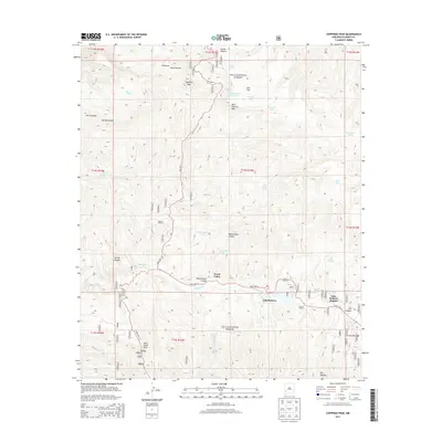
2013 Map of Copperas Peak
USGS Topo · Published 2013About this map
Lake Roberts and the community of Lake Roberts Heights serve as the central hub of this high-country landscape within the Gila National Forest. The geography is defined by a dense network of canyons and water-management features, ranging from Alum Canyon in the north to Meerschaum Canyon and Hill Canyon further south. The presence of numerous named tanks, such as Thirtytwo Tank and Gila Flat Tank Number Two, indicates the importance of water storage in this arid terrain. Topographical landmarks like Copperas Peak, Buck Hannen Mtn, and Wild Horse Mesa provide distinct navigational points through the forest. Transportation is primarily limited to State Hwy 15 and State Hwy 35, which intersect near Trout Valley, facilitating access to the various springs and drainages like Sapillo Cr that carve through the mesa country.
Find a feature on this map
43 named features on this map. Tap any name to fly to it.
Don’t see what you’re looking for? This feature index may not catch every label — zoom into the map to look around manually.
Map Details
Editions of this 2013 Copperas Peak Map
This is the sole edition of this map. No revisions or reprints were ever made.
Other maps of this area

1909 · Silver City
USGS Topo · 1:125,000

1911 · Alum Mountain
USGS Topo · 1:125,000

1913 · Alum Mountain
USGS Topo · 1:125,000

1947 · Allie Canyon
USGS Topo · 1:24,000

1947 · Twin Sisters
USGS Topo · 1:24,000

1948 · Twin Sisters
USGS Topo · 1:24,000

1948 · Allie Canyon
USGS Topo · 1:24,000

1950 · Reading Mountain
USGS Topo · 1:24,000
1952 · Reading Mountain
USGS Topo · 1:24,000

1954 · Silver City
USGS Topo · 1:250,000