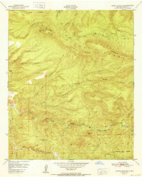
1952 Map of Reading Mountain
USGS Topo · Published 1952About this map
The Pinos Altos Range defines this high-elevation landscape within the Gila National Forest, where steep canyons and sharp ridgelines dominate the topography. Rising to prominent heights at Reading Mountain and Four Mountain, the terrain is carved by a network of seasonal drainages including Sycamore Creek and Bear Creek. Human presence is marked by isolated landmarks and ranching infrastructure, most notably the Snow Creek Cabin near the northern boundary and the Dorsey Ranch lands to the west. This 1952 study shows the area's transition from the high ridges of Tadpole Ridge down toward the southern drainage of Walnut Creek. Significant landmarks like Devils Garden and Preachers Point suggest a landscape used by ranchers and outdoorsmen long before modern development, while the absence of major roads emphasizes the backcountry character of the territory north of Silver City.
Find a feature on this map
41 named features on this map. Tap any name to fly to it.
Don’t see what you’re looking for? This feature index may not catch every label — zoom into the map to look around manually.
Map Details
Editions of this 1952 Reading Mountain Map
This is the sole edition of this map. No revisions or reprints were ever made.
Other maps of this area

1909 · Silver City
USGS Topo · 1:125,000

1911 · Alum Mountain
USGS Topo · 1:125,000

1913 · Alum Mountain
USGS Topo · 1:125,000

1947 · Twin Sisters
USGS Topo · 1:24,000

1947 · Fort Bayard
USGS Topo · 1:24,000

1948 · Twin Sisters
USGS Topo · 1:24,000

1949 · Fort Bayard
USGS Topo · 1:24,000

1949 · Circle Mesa
USGS Topo · 1:24,000

1950 · Dorsey Ranch
USGS Topo · 1:24,000

1950 · Silver City
USGS Topo · 1:24,000