
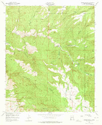
1950 Map of Dorsey Ranch
USGS Topo · Published 1963About this map
Gila National Forest encompasses the deep canyons and high mesas of this 1950 field survey in Grant County. The landscape is defined by its critical water sources, including Lee Spring, Seep Springs, and the notably named Dorsey Hole Spring, which supported the region's isolated ranching operations. Remote outposts such as the Burris H W Ranch, Avery Ranch, and Dorsey Ranch are connected by rugged terrain features like Hells Half Acre Canyon and Greenwood Canyon. Small-scale industrial activity is evidenced by a Quarry in the southeastern quadrant, while the Reading Canyon Trail suggests the early transit routes used by stockmen. The map reveals a land management pattern where named canyons like Stone Canyon and Windmill Canyon served as primary landmarks for navigating the high desert environment before modern development altered the southwestern corridor.
Find a feature on this map
32 named features on this map. Tap any name to fly to it.
Don’t see what you’re looking for? This feature index may not catch every label — zoom into the map to look around manually.
Map Details
Editions of this 1950 Dorsey Ranch Map
2 editions found
Other maps of this area

1909 · Silver City
USGS Topo · 1:125,000

1910 · Mogollon
USGS Topo · 1:125,000

1911 · Alum Mountain
USGS Topo · 1:125,000

1912 · Mogollon
USGS Topo · 1:125,000

1913 · Alum Mountain
USGS Topo · 1:125,000

1949 · Circle Mesa
USGS Topo · 1:24,000

1950 · Silver City
USGS Topo · 1:24,000

1950 · Reading Mountain
USGS Topo · 1:24,000

1951 · Circle Mesa
USGS Topo · 1:24,000

1951 · Dorsey Ranch
USGS Topo · 1:24,000