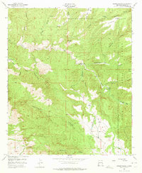
1950 Map of Dorsey Ranch
USGS Topo · Published 1975About this map
Gila National Forest ranching and mining landforms dominate this 1950s era survey of Grant County. The topography is defined by complex canyon systems and flat-topped mesas, including Slick Rock Mesa and Dorsey Mesa, which provided natural boundaries for early grazing operations. Significant family-named ranch sites such as the Dorsey Ranch, Burris H W Ranch, and Avery Ranch are marked, showing the remote settlement pattern in this corner of the state. Water sources were essential for survival here, evidenced by the location of Seep Springs, Lee Spring, and Dorsey Spring. A small Quarry in the southeastern quadrant and several windmills point to the modest industrial and agricultural infrastructure maintained in these high-altitude drainages, while the network of unimproved dirt roads and light-duty paths through Bear Creek and Greenwood Canyon illustrate the difficulty of early transit through the area.
Find a feature on this map
31 named features on this map. Tap any name to fly to it.
Don’t see what you’re looking for? This feature index may not catch every label — zoom into the map to look around manually.
Map Details
Editions of this 1950 Dorsey Ranch Map
2 editions found
Other maps of this area

1909 · Silver City
USGS Topo · 1:125,000

1910 · Mogollon
USGS Topo · 1:125,000

1911 · Alum Mountain
USGS Topo · 1:125,000

1912 · Mogollon
USGS Topo · 1:125,000

1913 · Alum Mountain
USGS Topo · 1:125,000

1949 · Circle Mesa
USGS Topo · 1:24,000

1950 · Dorsey Ranch
USGS Topo · 1:24,000

1950 · Silver City
USGS Topo · 1:24,000

1950 · Reading Mountain
USGS Topo · 1:24,000

1951 · Circle Mesa
USGS Topo · 1:24,000