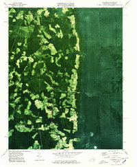
1977 Map of Corapeake
USGS Topo · Published 1978About this map
Great Dismal Swamp National Wildlife Refuge dominates the eastern half of this orthophotomap, where the dense canopy of the swamp is interrupted only by a rigid network of drainage channels. Features like Lateral Ditch Number One, South Ditch, and Corapeake Ditch define the boundary between the wild wetlands and the agricultural settlements to the west. This transition is marked by a landscape of small family-named cemeteries and rural crossroads that persist even as the surrounding environment dictates the limits of development.
Find a feature on this map
44 named features on this map. Tap any name to fly to it.
Don’t see what you’re looking for? This feature index may not catch every label — zoom into the map to look around manually.
Map Details
Editions of this 1977 Corapeake Map
2 editions found
Other maps of this area

1906 · Beckford
USGS Topo · 1:48,000

1907 · Beckford
USGS Topo · 1:62,500

1919 · Suffolk
USGS Topo · 1:62,500

1940 · Beckford
USGS Topo · 1:62,500

1940 · Lake Drummond
USGS Topo · 1:62,500

1940 · South Mills
USGS Topo · 1:62,500

1945 · Lake Drummond
USGS Topo · 1:62,500

1952 · South Mills
USGS Topo · 1:62,500

1953 · Norfolk
USGS Topo · 1:250,000
1954 · Buckhorn
USGS Topo · 1:24,000