
1977 Map of Corapeake
USGS Topo · Published 1987About this map
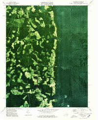
Great Dismal Swamp National Wildlife Refuge dominates the eastern half of this landscape, where the dark, saturated forest meets the engineered drainage systems of the late 1970s. This orthophotomap, based on 1973 aerial photography, reveals the stark contrast between the dense, undisturbed wetlands and the expanding agricultural clearings to the west. A complex network of canals and ditches, including Corapeake Ditch, Lateral Ditch Number One, and Cross Canal, illustrates long-standing efforts to manage the water levels of this ancient pocosin. Settlement is concentrated along higher ground, with the community of Corapeake and Holly Grove serving as anchors for the local rural population. Traces of historical industry and transportation appear in the form of a Railroad Grade and scattered cemeteries near Cypress Chapel, marking where human activity pushed against the edge of Dragon Swamp and Moss Swamp.
Find a feature on this map
32 named features on this map. Tap any name to fly to it.
Don’t see what you’re looking for? This feature index may not catch every label — zoom into the map to look around manually.
Map Details
Editions of this 1977 Corapeake Map
2 editions found
Other maps of this area

1906 · Beckford
USGS Topo · 1:48,000

1907 · Beckford
USGS Topo · 1:62,500

1919 · Suffolk
USGS Topo · 1:62,500

1940 · Beckford
USGS Topo · 1:62,500

1940 · Lake Drummond
USGS Topo · 1:62,500

1940 · South Mills
USGS Topo · 1:62,500

1945 · Lake Drummond
USGS Topo · 1:62,500

1952 · South Mills
USGS Topo · 1:62,500

1953 · Norfolk
USGS Topo · 1:250,000
1954 · Buckhorn
USGS Topo · 1:24,000