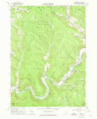
1965 Map of Corbett
USGS Topo · Published 1974About this map
The East Branch Delaware River winds through the heart of this mid-1960s Delaware County landscape, connecting the small riverfront communities of Shinhopple, Gregorytown, and Corbett. The terrain is defined by deep hollows and high ridges, much of it protected within the Catskill State Park and the Bear Spring Mountain Game Management Area. Notable for genealogists, several family-named burial grounds are documented, including Gregorytown Cem, Wilson Hollow Cem, and Harvard Cem. Transport and infrastructure are concentrated along the valley floor, evidenced by the Downsville Airport and a prominent Pumping Station and Gaging Station. The map captures a moment of established rural life in the Catskills, where local landmarks like the Horton Brook Ch and the Radio Tower on Bear Spring Mountain serve as anchor points in the heavily forested terrain.
Find a feature on this map
66 named features on this map. Tap any name to fly to it.
Don’t see what you’re looking for? This feature index may not catch every label — zoom into the map to look around manually.
Map Details
Editions of this 1965 Corbett Map
3 editions found
Other maps of this area

1920 · Long Eddy
USGS Topo · 1:62,500

1921 · Long Eddy
USGS Topo · 1:48,000

1921 · Livingston Manor
USGS Topo · 1:62,500

1922 · Andes
USGS Topo · 1:62,500

1923 · Long Eddy
USGS Topo · 1:62,500

1923 · Walton
USGS Topo · 1:48,000

1923 · Livingston Manor
USGS Topo · 1:62,500

1924 · Andes
USGS Topo · 1:62,500

1925 · Walton
USGS Topo · 1:62,500

1943 · Honesdale
USGS Topo · 1:125,000