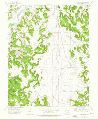
1972 Map of Corbin Canyon
USGS Topo · Published 1976About this map
The Purgatoire River winds through the northwestern corner of this landscape, cutting past Ninemile Valley and Gaum Canyon. This early 1970s survey captures a high-plains ranching environment at the intersection of Otero, Bent, and Las Animas Counties. The area is defined by a sophisticated network of water management, ranging from the engineered Two Buttes Canal to numerous localized stock watering points like Lemley Pond, Two Buttes Pond, and Harbordale Pond.
Find a feature on this map
42 named features on this map. Tap any name to fly to it.
Don’t see what you’re looking for? This feature index may not catch every label — zoom into the map to look around manually.
Map Details
Editions of this 1972 Corbin Canyon Map
2 editions found
Other maps of this area

1891 · Higbee
USGS Topo · 1:125,000

1891 · Timpas
USGS Topo · 1:125,000

1893 · Higbee
USGS Topo · 1:125,000

1894 · Timpas
USGS Topo · 1:125,000

1955 · La Junta
USGS Topo · 1:250,000

1958 · La Junta
USGS Topo · 1:250,000

1966 · La Junta SE
USGS Topo · 1:24,000
1966 · Turkey Canyon
USGS Topo · 1:24,000
1966 · Higbee
USGS Topo · 1:24,000

1968 · La Junta
USGS Topo · 1:250,000