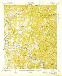
1947 Map of Corbin Knob
USGS Topo · Published 1947About this map
Franklin and the winding Cullasaja River dominate this 1946 field examination, revealing a landscape where mountain ridges dictate the placement of rural institutions. In the valley floors, the presence of the Nikwasi Indian Mound and the Franklin Airport contrast ancient history with mid-century aviation. Educational and spiritual life is densely mapped through a network of small schoolhouses and churches, such as Oak Ridge Sch, Mashburn Branch Sch, and Bethlehem Ch. The Nantahala National Forest covers much of the high ground, punctuated by numerous family-named peaks like Bryson Knob and Guy Knob. Near Higdonville, the terrain reveals the transition from valley agriculture to the steep slopes of the Cowee Mountains, where landmarks like Corundum Hill speak to the region's geological and mining heritage. The map also captures infrastructure including Lake Emory and a Gaging Station on the river.
Find a feature on this map
117 named features on this map. Tap any name to fly to it.
Don’t see what you’re looking for? This feature index may not catch every label — zoom into the map to look around manually.
Map Details
Editions of this 1947 Corbin Knob Map
2 editions found
Other maps of this area

1891 · Cowee
USGS Topo · 1:125,000

1897 · Cowee
USGS Topo · 1:125,000

1907 · Cowee
USGS Topo · 1:125,000

1933 · Bryson
USGS Topo · 1:62,500

1935 · Franklin
USGS Topo · 1:24,000

1935 · Prentiss
USGS Topo · 1:24,000

1935 · Cullowhee
USGS Topo · 1:24,000

1935 · Scaly
USGS Topo · 1:24,000

1935 · Glenville
USGS Topo · 1:24,000

1935 · Corbin Knob
USGS Topo · 1:24,000