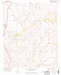
1974 Map of Cordes Junction
USGS Topo · Published 1977About this map
The Agua Fria River winds through this mid-1970s landscape, serving as a primary geographic anchor for the region south of the Prescott National Forest. The map documents the infrastructure of Cordes Junction, where the intersection of transit and terrain is highlighted by the Bloody Basin Interchange and a prominent Radio Tower. The area's ranching and aviation history is evidenced by the Horseshoe Ranch and its adjacent Landing Strip near the banks of the river.
Find a feature on this map
29 named features on this map. Tap any name to fly to it.
Don’t see what you’re looking for? This feature index may not catch every label — zoom into the map to look around manually.
Map Details
Editions of this 1974 Cordes Junction Map
2 editions found
Other maps of this area

1887 · Verde
USGS Topo · 1:250,000

1887 · Prescott
USGS Topo · 1:250,000

1892 · Verde
USGS Topo · 1:250,000

1892 · Prescott
USGS Topo · 1:250,000

1903 · Bradshaw Mountains
USGS Topo · 1:125,000

1929 · Turret Peak
USGS Topo · 1:125,000

1933 · Turret Peak
USGS Topo · 1:125,000

1947 · Bumblebee
USGS Topo · 1:62,500

1947 · Mayer
USGS Topo · 1:62,500

1948 · Bumblebee
USGS Topo · 1:63,360