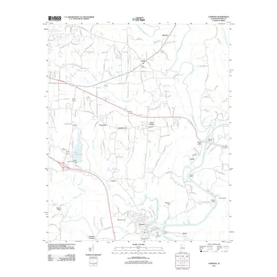
2011 Map of Cordova
USGS Topo · Published 2011About this map
The Mulberry Fork serpentines through the southern and eastern reaches of this Walker County landscape, defining the topography around Benoit and Sardis. This 2011 survey captures the industrial and community layout of Cordova, where the town sits between Reservoir Hill and the river's Benoit Bend. To the north, the terrain is dotted with small rural settlements and cemeteries that reflect the area's deep-rooted genealogy, including Union Chapel, Boldo, and Red Rock. The legacy of local extraction is evidenced by the Union Chapel Mine, while recreational and transport hubs like the Jasper Speedway and Walker County Lake highlight the modern development of the Jasper periphery. From the cotton-era namesake of Gardiners Gin to the family plots at Porter Cemetery, the map provides a look at the transition between established coal-country communities and the natural bends of the river valley.
Find a feature on this map
151 named features on this map. Tap any name to fly to it.
Don’t see what you’re looking for? This feature index may not catch every label — zoom into the map to look around manually.
Map Details
Editions of this 2011 Cordova Map
This is the sole edition of this map. No revisions or reprints were ever made.
Other maps of this area

1893 · Jasper
USGS Topo · 1:125,000

1935 · Port Birmingham
USGS Topo · 1:48,000

1938 · Port Birmingham
USGS Topo · 1:62,500

1949 · Cordova
USGS Topo · 1:24,000

1949 · Parrish
USGS Topo · 1:24,000

1949 · Sipsey
USGS Topo · 1:24,000

1949 · Cold Springs
USGS Topo · 1:24,000

1949 · Jasper
USGS Topo · 1:24,000

1949 · Manchester
USGS Topo · 1:24,000

1949 · Sunlight
USGS Topo · 1:24,000