
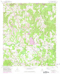
1949 Map of Manchester
USGS Topo · Published 1972About this map
Manchester and the surrounding rural communities of Walker County appear here during the late 1940s, a period when the landscape was defined by coal mining and agricultural life. The meandering path of Blackwater Creek serves as a central geographical feature, winding past Brakefield Bend and under the Johnsey Bridge. The presence of a Strip Mine near Marigold points to the area's industrial importance, while numerous country churches and schools like Thatch Jr High Sch and Lamons Chapel anchor the social fabric of these small settlements.
Find a feature on this map
46 named features on this map. Tap any name to fly to it.
Don’t see what you’re looking for? This feature index may not catch every label — zoom into the map to look around manually.
Map Details
Editions of this 1949 Manchester Map
2 editions found
Other maps of this area

1893 · Jasper
USGS Topo · 1:125,000

1949 · Cordova
USGS Topo · 1:24,000

1949 · Townley
USGS Topo · 1:24,000

1949 · Jasper
USGS Topo · 1:24,000

1949 · Nauvoo
USGS Topo · 1:24,000

1949 · Sunlight
USGS Topo · 1:24,000

1950 · Nauvoo
USGS Topo · 1:24,000

1950 · Manchester
USGS Topo · 1:24,000

1951 · Jasper
USGS Topo · 1:24,000

1951 · Townley
USGS Topo · 1:24,000