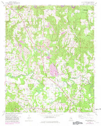
1949 Map of Manchester
USGS Topo · Published 1981About this map
Manchester and the surrounding Walker County countryside are defined by the winding course of Blackwater Creek and the expansion of surface mining in the mid-20th century. Large Strip Mine excavations, often indicated by purple revisions from the late 1970s, intersect with older rural landmarks like Thatch Jr High Sch and Lamons Chapel. The landscape is a mix of industry and tradition, where the Southern railroad serves the community at Gamble Sta, and timber stands are managed within the southern reaches of the Bankhead National Forest.
Find a feature on this map
47 named features on this map. Tap any name to fly to it.
Don’t see what you’re looking for? This feature index may not catch every label — zoom into the map to look around manually.
Map Details
Editions of this 1949 Manchester Map
2 editions found
Other maps of this area

1893 · Jasper
USGS Topo · 1:125,000

1949 · Cordova
USGS Topo · 1:24,000

1949 · Townley
USGS Topo · 1:24,000

1949 · Jasper
USGS Topo · 1:24,000

1949 · Manchester
USGS Topo · 1:24,000

1949 · Nauvoo
USGS Topo · 1:24,000

1949 · Sunlight
USGS Topo · 1:24,000

1950 · Nauvoo
USGS Topo · 1:24,000

1950 · Manchester
USGS Topo · 1:24,000

1951 · Jasper
USGS Topo · 1:24,000