
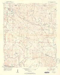
1950 Map of Nauvoo
USGS Topo · Published 1950About this map
Nauvoo stands as a focal point in the northwest corner of this terrain, situated where the northern and southern branches of the local landscape meet. During the late 1940s, the area's development was deeply influenced by its position within the William B Bankhead National Forest. This survey captures the rural character of the region, reflecting a moment before the widespread modernization of transport corridors and forest management that would reshape the Alabama interior. The map illustrates the specific layout of roads and natural features that defined daily life for the small communities established near the forest boundaries during this post-war era.
Find a feature on this map
1 named feature on this map. Tap any name to fly to it.
Don’t see what you’re looking for? This feature index may not catch every label — zoom into the map to look around manually.
Map Details
Editions of this 1950 Nauvoo Map
2 editions found
Other maps of this area

1893 · Jasper
USGS Topo · 1:125,000

1949 · Townley
USGS Topo · 1:24,000

1949 · Jasper
USGS Topo · 1:24,000

1949 · Manchester
USGS Topo · 1:24,000

1949 · Nauvoo
USGS Topo · 1:24,000

1950 · Manchester
USGS Topo · 1:24,000

1951 · Jasper
USGS Topo · 1:24,000

1951 · Townley
USGS Topo · 1:24,000

1953 · Birmingham
USGS Topo · 1:250,000

1956 · Birmingham
USGS Topo · 1:250,000