
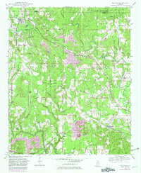
1949 Map of Nauvoo
USGS Topo · Published 1973About this map
Nauvoo and the surrounding borderlands of Winston Co and Walker Co are captured here during a period of transition in the late 1940s. The landscape is defined by the winding course of Blackwater Creek and its many tributaries, such as Little Blackwater Creek and Bunkum Creek. The Southern railroad line cuts through the terrain, connecting the coal-rich hills to larger markets, evidenced by a Strip Mine located near the northern boundary.
Find a feature on this map
55 named features on this map. Tap any name to fly to it.
Don’t see what you’re looking for? This feature index may not catch every label — zoom into the map to look around manually.
Map Details
Editions of this 1949 Nauvoo Map
2 editions found
Other maps of this area

1893 · Jasper
USGS Topo · 1:125,000

1949 · Townley
USGS Topo · 1:24,000

1949 · Jasper
USGS Topo · 1:24,000

1949 · Manchester
USGS Topo · 1:24,000

1950 · Nauvoo
USGS Topo · 1:24,000

1950 · Manchester
USGS Topo · 1:24,000

1951 · Jasper
USGS Topo · 1:24,000

1951 · Townley
USGS Topo · 1:24,000

1953 · Birmingham
USGS Topo · 1:250,000

1956 · Birmingham
USGS Topo · 1:250,000