
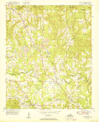
1950 Map of Manchester
USGS Topo · Published 1950About this map
William B Bankhead National Forest defines the northern reaches of this landscape, where the southern edge of the forest meets a patchwork of small farming communities and industrial infrastructure. The terrain is deeply etched by the winding Blackwater Creek and its many tributaries, including Crooked Creek and Charlies Creek. Settlement patterns are concentrated along these waterways and rural road junctions, anchored by local institutions like Thatch Jr High Sch and Antioch Ch.
Find a feature on this map
47 named features on this map. Tap any name to fly to it.
Don’t see what you’re looking for? This feature index may not catch every label — zoom into the map to look around manually.
Map Details
Editions of this 1950 Manchester Map
2 editions found
Other maps of this area

1893 · Jasper
USGS Topo · 1:125,000

1949 · Cordova
USGS Topo · 1:24,000

1949 · Townley
USGS Topo · 1:24,000

1949 · Jasper
USGS Topo · 1:24,000

1949 · Manchester
USGS Topo · 1:24,000

1949 · Nauvoo
USGS Topo · 1:24,000

1949 · Sunlight
USGS Topo · 1:24,000

1950 · Nauvoo
USGS Topo · 1:24,000

1951 · Jasper
USGS Topo · 1:24,000

1951 · Townley
USGS Topo · 1:24,000