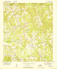
1950 Map of Manchester
USGS Topo · Published 1950About this map
The Alabama Central RR and Southern RR converge in this mid-century landscape, framing the growth of Manchester and surrounding rural communities. Industry is clearly visible in the extensive Strip Mine workings north of Marigold, while the southern reaches show a shift toward social centers like the Musgrove Country Club and Five Points. The topographic survey reveals a deeply local infrastructure of named crossings, such as Johnsey Bridge and Harris Bridge over Blackwater Creek.
Find a feature on this map
49 named features on this map. Tap any name to fly to it.
Don’t see what you’re looking for? This feature index may not catch every label — zoom into the map to look around manually.
Map Details
Editions of this 1950 Manchester Map
2 editions found
Other maps of this area

1893 · Jasper
USGS Topo · 1:125,000

1949 · Cordova
USGS Topo · 1:24,000

1949 · Townley
USGS Topo · 1:24,000

1949 · Jasper
USGS Topo · 1:24,000

1949 · Manchester
USGS Topo · 1:24,000

1949 · Nauvoo
USGS Topo · 1:24,000

1949 · Sunlight
USGS Topo · 1:24,000

1950 · Nauvoo
USGS Topo · 1:24,000

1950 · Manchester
USGS Topo · 1:24,000

1951 · Jasper
USGS Topo · 1:24,000