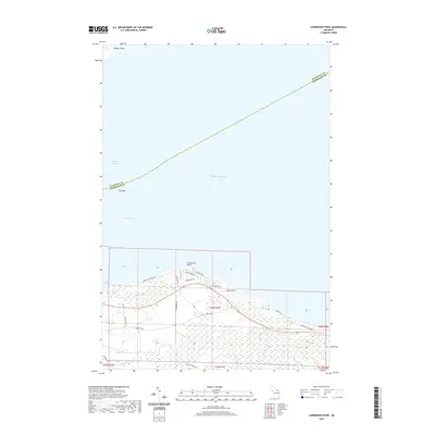
2019 Map of Cordwood Point
USGS Topo · Published 2019About this map
Cordwood Point marks a prominent landform at the transition between the Straits of Mackinac and the open waters of Lake Huron. This 2019 survey captures the developed residential character of the shoreline, where a network of private roads like Cordwood Shores Dr and Cedarhurst Dr follow the natural curve of the bay. Offshore, the map notes Poe Reef, a critical navigational hazard within the South Channel, which has long served as a vital maritime corridor for Great Lakes shipping. Farther north across the water, the southern tip of Bois Blanc Island is visible at Walkers Point. The interior landscape remains largely dominated by wetlands and forested areas, traversed by local routes such as Mackinaw Straits Dr and Huron Trl, illustrating the seasonal and recreational focus of this coastal region.
Find a feature on this map
28 named features on this map. Tap any name to fly to it.
Don’t see what you’re looking for? This feature index may not catch every label — zoom into the map to look around manually.
Map Details
Editions of this 2019 Cordwood Point Map
This is the sole edition of this map. No revisions or reprints were ever made.
Other maps of this area

1955 · Cheboygan
USGS Topo · 1:250,000

1957 · Cheboygan
USGS Topo · 1:62,500

1958 · Cheboygan
USGS Topo · 1:250,000

1958 · Grace
USGS Topo · 1:62,500

1964 · McRae Bay
USGS Topo · 1:24,000

1982 · Cordwood Point
USGS Topo · 1:25,000

1982 · Cheboygan
USGS Topo · 1:25,000

1982 · Grace
USGS Topo · 1:24,000

1982 · Aloha
USGS Topo · 1:25,000
1982 · Nilemile Point
USGS Topo · 1:25,000