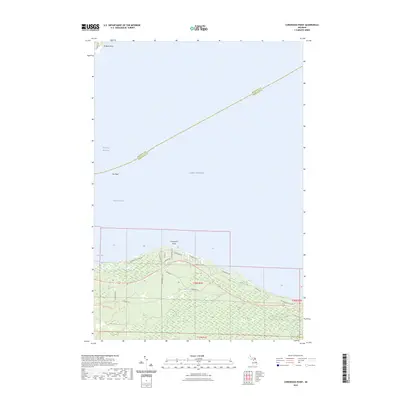
2023 Map of Cordwood Point
USGS Topo · Published 2023About this map
Cordwood Point marks a prominent bend in the northern Michigan shoreline where the Lake Huron waters meet the South Channel. This 2023 survey illustrates a landscape defined by its coastal orientation, where residential corridors like Cordwood Shores Dr and Lakewood Dr follow the contour of the lake. Further inland, the terrain is traversed by the Black Lake Trl and Huron Trl, indicating a network of secondary roads and pathways through the low-lying coastal forests. To the north, the map extends into the open waters of the Straits of Mackinac, detailing maritime landmarks such as Poe Reef and Walkers Point. The transition from the developed shoreline at Grass Bay to the more interior township lines of t38n r1e and t37n r1e reveals the modern spatial organization of Cheboygan County.
Find a feature on this map
28 named features on this map. Tap any name to fly to it.
Don’t see what you’re looking for? This feature index may not catch every label — zoom into the map to look around manually.
Map Details
Editions of this 2023 Cordwood Point Map
This is the sole edition of this map. No revisions or reprints were ever made.
Other maps of this area

1955 · Cheboygan
USGS Topo · 1:250,000

1957 · Cheboygan
USGS Topo · 1:62,500

1958 · Cheboygan
USGS Topo · 1:250,000

1958 · Grace
USGS Topo · 1:62,500

1964 · McRae Bay
USGS Topo · 1:24,000

1982 · Cordwood Point
USGS Topo · 1:25,000

1982 · Cheboygan
USGS Topo · 1:25,000

1982 · Grace
USGS Topo · 1:24,000

1982 · Aloha
USGS Topo · 1:25,000
1982 · Nilemile Point
USGS Topo · 1:25,000