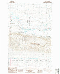
1986 Map of Corfu
USGS Topo · Published 1986About this map
The Saddle Mountains dominate this 1986 topographic survey, rising sharply above the desert floor and separating the Columbia National Wildlife Refuge to the north from the restricted landscape of the Hanford Site (DOE) to the south. This era shows a region of transition, where the natural watercourse of Crab Creek and its lower reach, Lower Crab Creek, meander through a basin increasingly shaped by water management. The irrigation infrastructure is clearly marked by the Wahluke Branch Canal following the southern base of the range. For those interested in local history, the map identifies both the settlement of Corfu and a separate location noted as Corfu (Site), suggesting the movement or evolution of the community over time. The southern half of the map is largely dedicated to the Wahluke Slope Habitat Management Area, showcasing the intersection of federal conservation and nuclear reservation boundaries.
Find a feature on this map
18 named features on this map. Tap any name to fly to it.
Don’t see what you’re looking for? This feature index may not catch every label — zoom into the map to look around manually.
Map Details
Editions of this 1986 Corfu Map
This is the sole edition of this map. No revisions or reprints were ever made.
Other maps of this area

1911 · Red Rock
USGS Topo · 1:62,500

1916 · Coyote Rapids
USGS Topo · 1:62,500

1923 · Corfu
USGS Topo · 1:62,500

1924 · Hanford
USGS Topo · 1:62,500

1950 · Smyrna
USGS Topo · 1:62,500

1951 · Smyrna
USGS Topo · 1:62,500

1951 · Corfu
USGS Topo · 1:62,500

1951 · Hanford
USGS Topo · 1:62,500

1951 · Coyote Rapids
USGS Topo · 1:62,500

1953 · Walla Walla
USGS Topo · 1:250,000