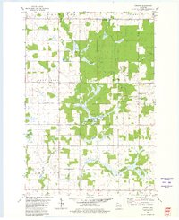
1980 Map of Corinth
USGS Topo · Published 1980About this map
The Big Eau Pleine River and its East Branch carve through the southern reaches of this landscape near the border of Taylor and Marathon Counties. In this rural Wisconsin setting, the small settlement of Corinth serves as a focal point, situated along the Old Railroad Grade and near a local Townhall. The area is characterized by a mix of agricultural land and wooded sections, including the expansive Bern State Public Hunting Grounds which spans much of the central terrain. Local infrastructure is sparse but notable, including the Kreie Sch and several Gravel Pits, indicating the region's reliance on primary resources and traditional township organization. Numerous creeks like Black Creek and Beaver Cr drain the northern townships of Browning, Goodrich, and Deer Creek, illustrating the intricate water network that defines the local geography.
Find a feature on this map
19 named features on this map. Tap any name to fly to it.
Don’t see what you’re looking for? This feature index may not catch every label — zoom into the map to look around manually.
Map Details
Editions of this 1980 Corinth Map
This is the sole edition of this map. No revisions or reprints were ever made.
Other maps of this area

1902 · Marathon
USGS Topo · 1:125,000

1951 · Athens
USGS Topo · 1:48,000

1951 · Medford
USGS Topo · 1:48,000

1953 · Abbotsford
USGS Topo · 1:48,000

1953 · Stratford
USGS Topo · 1:48,000

1953 · Eau Claire
USGS Topo · 1:250,000

1953 · Rice Lake
USGS Topo · 1:250,000

1958 · Eau Claire
USGS Topo · 1:250,000

1959 · Rice Lake
USGS Topo · 1:250,000

1963 · Stratford
USGS Topo · 1:62,500