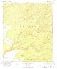
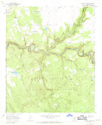
1978 Map of Corn Creek
USGS Topo · Published 1978About this map
Fort Apache Indian Reservation encompasses this high-elevation landscape, where deep drainages like Mountain Lion Canyon and Big Bonito Creek carve through the terrain. The map reflects a remote ranching and grazing economy during the late 1970s, evidenced by isolated outposts such as the KL Ranch, ID Ranch, and the John Hall Cabin. Water management is central to life in this arid environment, with numerous man-made features like Upper Corn Creek Tank, Tonto Rim Tank, and Willow Trap Tank distributed across the drainages. A network of primitive transport routes, marked simply as Jeep Trail and Trail, connect these points of interest, while a Gaging Station on Turkey Creek and a Borrow Pit indicate localized infrastructure and resource extraction efforts within the reservation boundaries.
Find a feature on this map
25 named features on this map. Tap any name to fly to it.
Don’t see what you’re looking for? This feature index may not catch every label — zoom into the map to look around manually.
Map Details
Editions of this 1978 Corn Creek Map
This is the sole edition of this map. No revisions or reprints were ever made.
Other maps of this area

1954 · Clifton
USGS Topo · 1:250,000

1957 · Clifton
USGS Topo · 1:250,000

1958 · Clifton
USGS Topo · 1:250,000

1962 · Clifton
USGS Topo · 1:250,000

1967 · Marshall Butte
USGS Topo · 1:24,000
1967 · Corn Creek Plateau
USGS Topo · 1:24,000
1967 · Maverick SW
USGS Topo · 1:24,000
1967 · West Poker Mtn.
USGS Topo · 1:24,000

1967 · Odart Mtn
USGS Topo · 1:24,000
1967 · Elwood Canyon
USGS Topo · 1:24,000