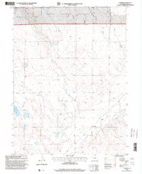
1997 Map of Cornish
USGS Topo · Published 2000About this map
The Pawnee National Grassland dominates the northern landscape of this Weld County quadrangle, where the high plains transition into a complex network of intermittent drainages. The settlement of Cornish is positioned at a junction near Crow Creek, while other named locales like Anderson and Wilson reflect the sparse, agrarian settlement pattern of the region. Water management is central to the area's geography, evidenced by the presence of Long Lake and various named ditches that carve through the prairie to support livestock and agriculture. The terrain is defined by the winding paths of Coal Creek and Sand Creek, alongside infrastructure such as a prominent north-south Pipeline and several water tanks that reveal the logistical requirements of maintaining rural Colorado ranching operations like the Flying G Ranch.
Find a feature on this map
15 named features on this map. Tap any name to fly to it.
Don’t see what you’re looking for? This feature index may not catch every label — zoom into the map to look around manually.
Map Details
Editions of this 1997 Cornish Map
This is the sole edition of this map. No revisions or reprints were ever made.
Other maps of this area

1902 · Greeley
USGS Topo · 1:125,000

1908 · Eaton
USGS Topo · 1:125,000

1910 · Eaton
USGS Topo · 1:125,000

1950 · Kersey
USGS Topo · 1:24,000

1950 · Barnesville
USGS Topo · 1:24,000

1951 · Point Of Rocks
USGS Topo · 1:24,000

1954 · Greeley
USGS Topo · 1:250,000

1957 · Greeley
USGS Topo · 1:250,000

1958 · Greeley
USGS Topo · 1:250,000

1960 · Purcell
USGS Topo · 1:24,000