
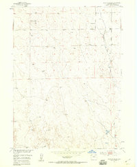
1951 Map of Point Of Rocks
USGS Topo · Published 1953About this map
The high plains of eastern Weld County are defined by sparse development and the vital necessity of water infrastructure in this 1951 survey. Centered on the distinctive terrain of Point of Rocks, the landscape is primarily organized around the drainage of Sanborn Draw, which cuts through the arid rangeland. Human presence is evidenced by a network of ranching improvements, including numerous Windmills and a specific Water Tank that supported livestock in this portion of the Missouri River Basin. The presence of the Praira School in the northeastern section suggests a once-active rural school district serving the surrounding homesteads. This map captures a specific moment in the mid-century development of Colorado's ranching frontier, documenting the exact locations of essential water sources and the local institutions that sustained small cattle-raising communities.
Find a feature on this map
6 named features on this map. Tap any name to fly to it.
Don’t see what you’re looking for? This feature index may not catch every label — zoom into the map to look around manually.
Map Details
Editions of this 1951 Point Of Rocks Map
2 editions found
Other maps of this area

1950 · Greasewood Lake
USGS Topo · 1:24,000

1950 · Barnesville
USGS Topo · 1:24,000

1950 · Masters
USGS Topo · 1:24,000

1950 · Hardin
USGS Topo · 1:24,000

1951 · Masters
USGS Topo · 1:24,000

1951 · Hardin
USGS Topo · 1:24,000
1951 · Dearfield
USGS Topo · 1:24,000

1954 · Greeley
USGS Topo · 1:250,000

1957 · Greeley
USGS Topo · 1:250,000

1958 · Greeley
USGS Topo · 1:250,000