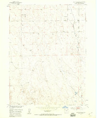
1951 Map of Point Of Rocks
USGS Topo · Published 1958About this map
Point of Rocks stands as a prominent topographical landmark in this section of Weld County, surveyed in the early 1950s as part of the Department of the Interior’s program for the Missouri River Basin. The landscape is defined by the ephemeral path of Sanborn Draw, which cuts through the eastern portion of the quadrangle. This area represents a classic high-plains ranching environment, where the infrastructure of survival is clearly marked by a sparse but essential network of water sources. The map reveals numerous Windmill and Windmills sites scattered across the sections, indicating the necessity of groundwater for livestock and homesteads. The Praira School and a lone Water Tank serve as the primary human identifiers in a territory otherwise shaped by undulating terrain and township lines.
Find a feature on this map
7 named features on this map. Tap any name to fly to it.
Don’t see what you’re looking for? This feature index may not catch every label — zoom into the map to look around manually.
Map Details
Editions of this 1951 Point Of Rocks Map
2 editions found
Other maps of this area

1950 · Greasewood Lake
USGS Topo · 1:24,000

1950 · Barnesville
USGS Topo · 1:24,000

1950 · Masters
USGS Topo · 1:24,000

1950 · Hardin
USGS Topo · 1:24,000

1951 · Masters
USGS Topo · 1:24,000

1951 · Hardin
USGS Topo · 1:24,000

1951 · Point Of Rocks
USGS Topo · 1:24,000
1951 · Dearfield
USGS Topo · 1:24,000

1954 · Greeley
USGS Topo · 1:250,000

1957 · Greeley
USGS Topo · 1:250,000