
1950 Map of Masters
USGS Topo · Published 1966About this map
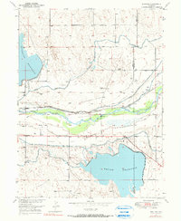
The South Platte River corridor dominates this 1950 survey, revealing a landscape defined by complex irrigation and transportation infrastructure along the border of Weld and Morgan Counties. The small settlement of Masters is the primary hub, served by the Union Pacific railroad and its own Masters P O. Between the river and the northern uplands, the Green City Flats highlight the flat terrain that supported early agricultural development in this part of Colorado.
Find a feature on this map
19 named features on this map. Tap any name to fly to it.
Don’t see what you’re looking for? This feature index may not catch every label — zoom into the map to look around manually.
Map Details
Editions of this 1950 Masters Map
2 editions found
Other maps of this area

1950 · Wiggins
USGS Topo · 1:24,000

1950 · Greasewood Lake
USGS Topo · 1:24,000

1951 · Masters
USGS Topo · 1:24,000

1951 · Orchard
USGS Topo · 1:24,000

1951 · Roggen
USGS Topo · 1:24,000

1951 · Sunken Lake
USGS Topo · 1:24,000

1951 · Omar
USGS Topo · 1:24,000

1951 · Point Of Rocks
USGS Topo · 1:24,000
1951 · Dearfield
USGS Topo · 1:24,000

1954 · Greeley
USGS Topo · 1:250,000