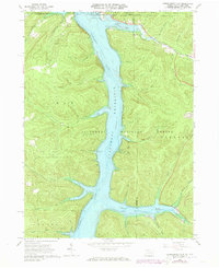
1966 Map of Cornplanter Run
USGS Topo · Published 1973About this map
The Allegheny Reservoir dominates this 1973 photorevised landscape, showing the massive impact of the Kinzua Dam on the valley along the New York and Pennsylvania border. This era marks a significant transformation for the region, with the reservoir's waters at Normal Pool Elev 1328 submerging former valley floor lands once occupied by the Seneca Nation and local settlers. The Allegany Indian Reservation and the Allegheny National Forest meet here, with recreation sites like Willow Bay Recreation Area and Hooks Brook Campground replacing older river-bottom uses. Evidence of the region’s resource history remains visible through numerous Oil Wells and gas wells scattered across the upland ridges. Local history is anchored by the Riverview-Corydon Cem and numerous named drainages like Cornplanter Run and Hodge Run that feed into the expansive new lake system.
Find a feature on this map
50 named features on this map. Tap any name to fly to it.
Don’t see what you’re looking for? This feature index may not catch every label — zoom into the map to look around manually.
Map Details
Editions of this 1966 Cornplanter Run Map
4 editions found
Other maps of this area

1905 · Jamestown
USGS Topo · 1:62,500

1906 · Warren
USGS Topo · 1:62,500

1907 · Warren
USGS Topo · 1:62,500

1908 · Warren
USGS Topo · 1:62,500

1922 · Randolph
USGS Topo · 1:62,500

1923 · Randolph
USGS Topo · 1:62,500

1936 · Kinzua
USGS Topo · 1:48,000

1941 · Kinzua
USGS Topo · 1:62,500

1942 · Jamestown
USGS Topo · 1:62,500

1943 · Randolph
USGS Topo · 1:62,500