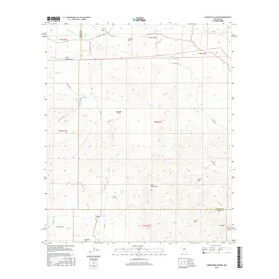
2017 Map of Cornucopia Canyon
USGS Topo · Published 2017About this map
Cornucopia Canyon cuts through this high desert plateau along the boundary between Chaves and Otero counties. The landscape is defined by an intricate network of drainage features like Little Collins Draw, Barclay Draw, and Fleming Draw, illustrating the complex hydrology of the region. This 2017 survey reveals the vital importance of water management in this arid environment, evidenced by the high density of named stock tanks and catchment basins. Features such as Alva Smith Tanks, Fred Tank, School Tank, and John Gentry Tank are distributed across the terrain, reflecting the area's continued use for ranching and livestock. A series of county roads, including Cornucopia Canyon Rd and Shockley Lake Rd, provide access to this remote portion of New Mexico's rangeland, while Dry Peak stands as a prominent topographical marker near the southern edge of the quadrangle.
Find a feature on this map
49 named features on this map. Tap any name to fly to it.
Don’t see what you’re looking for? This feature index may not catch every label — zoom into the map to look around manually.
Map Details
Editions of this 2017 Cornucopia Canyon Map
This is the sole edition of this map. No revisions or reprints were ever made.
Other maps of this area

1954 · Carlsbad
USGS Topo · 1:250,000

1958 · Carlsbad
USGS Topo · 1:250,000

1963 · Cornucopia Canyon
USGS Topo · 1:24,000

1963 · Tanner Ranch
USGS Topo · 1:24,000

1963 · Indian Draw
USGS Topo · 1:24,000

1965 · Chimney Lake
USGS Topo · 1:24,000

1965 · Lewis Peak
USGS Topo · 1:24,000

1965 · Avis
USGS Topo · 1:24,000

1965 · Pinon
USGS Topo · 1:24,000

1965 · Pinon Ranch
USGS Topo · 1:24,000