
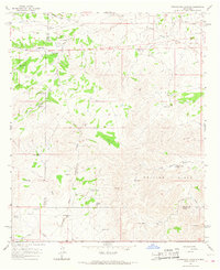
1965 Map of Lewis Peak
USGS Topo · Published 1967About this map
Isolated cattle operations and water management systems define this high-altitude landscape in Chaves County. Neatherlin Ranch, Tidwell Ranch, and Cauhape Ranch anchor the territory, connected by an sparse network of unimproved roads and a Jeep Trail winding through the complex drainages of Cox Canyon and Fourmile Canyon. The reliance on artificial water storage is evident through several tanks, such as Cox Tank and Lee Tank, alongside the Pretty Bird Windmill in the eastern hills.
Find a feature on this map
18 named features on this map. Tap any name to fly to it.
Don’t see what you’re looking for? This feature index may not catch every label — zoom into the map to look around manually.
Map Details
Editions of this 1965 Lewis Peak Map
This is the sole edition of this map. No revisions or reprints were ever made.
Other maps of this area

1954 · Carlsbad
USGS Topo · 1:250,000

1958 · Carlsbad
USGS Topo · 1:250,000

1962 · Dunken
USGS Topo · 1:62,500

1963 · Cornucopia Canyon
USGS Topo · 1:24,000

1963 · Robertson Canyon
USGS Topo · 1:24,000

1965 · Lewis Peak NE
USGS Topo · 1:24,000

1965 · Chimney Lake
USGS Topo · 1:24,000

1965 · Bullis Spring Ranch
USGS Topo · 1:24,000

1965 · Pinon Ranch
USGS Topo · 1:24,000
1965 · Cornucopia Canyon
USGS Topo · 1:24,000