
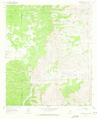
1963 Map of Robertson Canyon
USGS Topo · Published 1967About this map
Lincoln National Forest dominates this landscape along the border of Otero and Chaves counties. The topography is defined by a dense network of drainages including Robertson Canyon, Cuevo Canyon, and Angel Canyon, which cut through the high terrain to form localized basins like McDonald Flat. This 1963 survey records the sparse ranching infrastructure of the era, highlighting family-named operations such as the Jernigan Ranch and KOK Ranch situated near the canyon floors where water was more accessible.
Find a feature on this map
27 named features on this map. Tap any name to fly to it.
Don’t see what you’re looking for? This feature index may not catch every label — zoom into the map to look around manually.
Map Details
Editions of this 1963 Robertson Canyon Map
2 editions found
Other maps of this area

1954 · Carlsbad
USGS Topo · 1:250,000

1958 · Carlsbad
USGS Topo · 1:250,000

1962 · Dunken
USGS Topo · 1:62,500

1963 · Mayhill
USGS Topo · 1:24,000

1963 · Woodson Canyon
USGS Topo · 1:24,000
1963 · Elk
USGS Topo · 1:24,000

1965 · Chimney Lake
USGS Topo · 1:24,000

1965 · Lewis Peak
USGS Topo · 1:24,000

1965 · Avis
USGS Topo · 1:24,000

1979 · Alamogordo
USGS Topo · 1:100,000