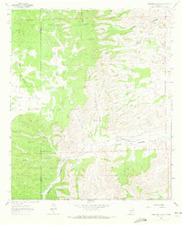
1963 Map of Robertson Canyon
USGS Topo · Published 1972About this map
Lincoln National Forest land dominates this high-country landscape, where the Chaves and Otero county lines intersect among a complex network of drainage systems. The terrain is defined by deep incisions like Robertson Canyon, Cuevo Canyon, and Angel Canyon, which channel seasonal runoff through the arid plateau. Human presence is sparse and largely tied to ranching and water management, evidenced by small upland catchments such as Mule Canyon Tank and the South Pasture Tank No 1. Isolated landmarks like the Jernigan Ranch and the Cox Cem provide rare genealogical anchor points in this remote portion of the Sacramento Mountains. The map also captures specific industrial and geological features, including a Gravel Pit and several small bodies of water like Hale Lake and Boat Lake situated on the broader expanse of McDonald Flat.
Find a feature on this map
25 named features on this map. Tap any name to fly to it.
Don’t see what you’re looking for? This feature index may not catch every label — zoom into the map to look around manually.
Map Details
Editions of this 1963 Robertson Canyon Map
2 editions found
Other maps of this area

1954 · Carlsbad
USGS Topo · 1:250,000

1958 · Carlsbad
USGS Topo · 1:250,000

1962 · Dunken
USGS Topo · 1:62,500

1963 · Mayhill
USGS Topo · 1:24,000

1963 · Robertson Canyon
USGS Topo · 1:24,000

1963 · Woodson Canyon
USGS Topo · 1:24,000
1963 · Elk
USGS Topo · 1:24,000

1965 · Chimney Lake
USGS Topo · 1:24,000

1965 · Lewis Peak
USGS Topo · 1:24,000

1965 · Avis
USGS Topo · 1:24,000