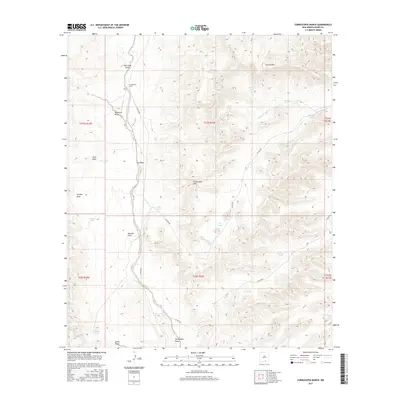
2017 Map of Cornucopia Ranch
USGS Topo · Published 2017About this map
Cornucopia Ranch sits at the heart of this Otero County landscape, where an intricate network of desert water management defines the human footprint. The map reveals a high-altitude arid environment structured around named tanks and catchments, such as Middle Rincon Tank, Venada Tank, and El Paso Tank, essential for sustaining livestock and life in this drainage-rich terrain. These water features are strategically situated near landforms like the Cornucopia Hills and Collins Hills.
Find a feature on this map
34 named features on this map. Tap any name to fly to it.
Don’t see what you’re looking for? This feature index may not catch every label — zoom into the map to look around manually.
Map Details
Editions of this 2017 Cornucopia Ranch Map
This is the sole edition of this map. No revisions or reprints were ever made.
Other maps of this area

1954 · Carlsbad
USGS Topo · 1:250,000

1958 · Carlsbad
USGS Topo · 1:250,000

1963 · Cornucopia Canyon
USGS Topo · 1:24,000

1963 · Hackberry Hill
USGS Topo · 1:24,000
1963 · Cornucopia Ranch SE
USGS Topo · 1:24,000

1963 · Tanner Ranch
USGS Topo · 1:24,000

1963 · Indian Draw
USGS Topo · 1:24,000

1963 · Cleones Tank
USGS Topo · 1:24,000

1965 · Pinon
USGS Topo · 1:24,000

1965 · Pinon Ranch
USGS Topo · 1:24,000