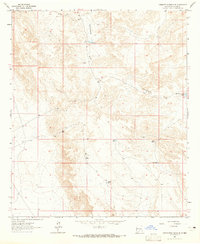
1963 Map of Cornucopia Ranch SE
USGS Topo · Published 1965About this map
Runyan Line Shack stands as a solitary human marker in this arid Otero County landscape, centered on the drainage systems of Lucky Draw and the extensive Cornucopia Draw. The map reveals a land managed for water, featuring the Cornucopia Diversion Dam and a network of artificial catchments including East Tank, Rock Tank, and Double Tank. These features suggest a ranching economy dependent on captured runoff in a region where natural permanent water is scarce. A single Drill Hole in section 8 and various unimproved dirt roads and fence lines further indicate the sparse but intentional use of this territory. The terrain is defined by its complex contouring and seasonal watercourses, reflecting the environmental challenges faced by mid-century land users in this part of New Mexico.
Find a feature on this map
16 named features on this map. Tap any name to fly to it.
Don’t see what you’re looking for? This feature index may not catch every label — zoom into the map to look around manually.
Map Details
Editions of this 1963 Cornucopia Ranch SE Map
This is the sole edition of this map. No revisions or reprints were ever made.
Other maps of this area

1954 · Carlsbad
USGS Topo · 1:250,000

1958 · Carlsbad
USGS Topo · 1:250,000

1963 · Hackberry Hill
USGS Topo · 1:24,000

1963 · Tanner Ranch
USGS Topo · 1:24,000

1963 · Indian Draw
USGS Topo · 1:24,000

1963 · Cleones Tank
USGS Topo · 1:24,000

1969 · Lewis Canyon
USGS Topo · 1:24,000

1970 · Shiloh Hills
USGS Topo · 1:24,000
1970 · Van Winkle Lake
USGS Topo · 1:24,000

1979 · Crow Flats
USGS Topo · 1:100,000