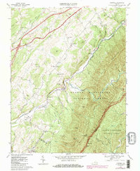
1967 Map of Cornwall
USGS Topo · Published 1986About this map
The South River valley serves as a primary corridor for transportation and settlement in this portion of the Shenandoah Valley during the mid-to-late 20th century. The Norfolk and Western Railroad tracks parallel the river, passing through the industrial and residential nodes of Cornwall and Midvale. This rail-and-river network supported localized industry, evidenced by a Mine and Quarry situated near the Blue Ridge foothills.
Find a feature on this map
63 named features on this map. Tap any name to fly to it.
Don’t see what you’re looking for? This feature index may not catch every label — zoom into the map to look around manually.
Map Details
Editions of this 1967 Cornwall Map
3 editions found
Other maps of this area

1894 · Lexington
USGS Topo · 1:125,000

1932 · Lexington
USGS Topo · 1:48,000

1935 · Buena Vista
USGS Topo · 1:48,000

1935 · Amherst
USGS Topo · 1:48,000

1936 · Vesuvius
USGS Topo · 1:48,000

1937 · Lexington
USGS Topo · 1:62,500

1939 · Amherst
USGS Topo · 1:62,500

1939 · Buena Vista
USGS Topo · 1:62,500

1940 · Buena Vista
USGS Topo · 1:62,500

1941 · Vesuvius
USGS Topo · 1:62,500