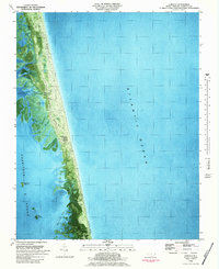
1982 Map of Corolla
USGS Topo · Published 1983About this map
Currituck Beach is defined by the thin, shifting barrier between the Atlantic Ocean and Currituck Sound in the early 1980s. This orthophotomap combines traditional topographic contour lines with aerial photography taken in 1977, revealing the delicate marshlands of Jenkins Cove and Ships Bay. The settlement of Corolla anchors the southern end of this sheet, marked by the iconic Currituck Beach Lighthouse and a solitary Light.
Find a feature on this map
16 named features on this map. Tap any name to fly to it.
Don’t see what you’re looking for? This feature index may not catch every label — zoom into the map to look around manually.
Map Details
Editions of this 1982 Corolla Map
2 editions found
Other maps of this area

1893 · Virginia Beach
USGS Topo · 1:125,000

1916 · Back Bay
USGS Topo · 1:62,500

1940 · Barco
USGS Topo · 1:62,500

1943 · Back Bay
USGS Topo · 1:62,500

1946 · Eastville
USGS Topo · 1:250,000

1946 · Currituck Sound
USGS Topo · 1:250,000
1954 · Knotts Island
USGS Topo · 1:24,000

1961 · Eastville
USGS Topo · 1:250,000

1966 · Eastville
USGS Topo · 1:250,000
1982 · Barco
USGS Topo · 1:24,000