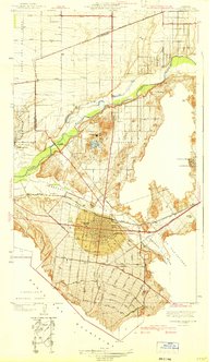
1942 Map of Corona and Vicinity
USGS Topo · Published 1942About this map
Corona sits at the heart of this landscape, its grid organized by iconic thoroughfares like Ontario Avenue and Magnolia Avenue during an era of significant citrus production and local development. The drainage of the Santa Ana River and the Temescal Wash dominates the terrain, with the Sierra De San Jacinto and the Santa Ana Mountains framing the basin. North of town, the specialized character of Norco is visible near Lake Norconian, a site of notable social and architectural prominence at the time of the survey.
Find a feature on this map
39 named features on this map. Tap any name to fly to it.
Don’t see what you’re looking for? This feature index may not catch every label — zoom into the map to look around manually.
Map Details
Editions of this 1942 Corona and Vicinity Map
This is the sole edition of this map. No revisions or reprints were ever made.
Other maps of this area

1896 · San Bernardino
USGS Topo · 1:62,500

1897 · Cucamonga
USGS Topo · 1:62,500

1898 · San Bernardino
USGS Topo · 1:62,500

1900 · Cucamonga
USGS Topo · 1:62,500

1901 · Southern California Sheet No. 1
USGS Topo · 1:250,000

1901 · San Bernardino
USGS Topo · 1:62,500

1901 · Elsinore
USGS Topo · 1:125,000

1901 · Riverside
USGS Topo · 1:62,500

1902 · Corona
USGS Topo · 1:125,000

1903 · Cucamonga
USGS Topo · 1:62,500