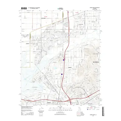
2015 Map of Corona North
USGS Topo · Published 2015About this map
The Santa Ana River carves through this dense corridor of Riverside and San Bernardino counties, acting as a natural boundary between the expanding suburban grids and flood control zones. To the south, the city of Corona is framed by its municipal airport and the industrial activity around Porphyry, while the prominent Lake Norconian sits at the heart of Norco. The landscape transitions from the residential developments of Eastvale and Jurupa Valley to the infrastructure-heavy wetlands of the Prado Flood Control Basin. Aviation history is well-represented here, with both Chino Airport and the Corona Municipal Airport serving the region. Large-scale transit networks are evident in the BNSF Railway lines and the major thoroughfares like Limonite Ave and Hidden Valley Pky, which connect these established communities with the surrounding foothills near La Sierra Heights.
Find a feature on this map
67 named features on this map. Tap any name to fly to it.
Don’t see what you’re looking for? This feature index may not catch every label — zoom into the map to look around manually.
Map Details
Editions of this 2015 Corona North Map
This is the sole edition of this map. No revisions or reprints were ever made.
Other maps of this area

1896 · San Bernardino
USGS Topo · 1:62,500

1897 · Cucamonga
USGS Topo · 1:62,500

1898 · San Bernardino
USGS Topo · 1:62,500

1900 · Cucamonga
USGS Topo · 1:62,500

1901 · Southern California Sheet No. 1
USGS Topo · 1:250,000

1901 · San Bernardino
USGS Topo · 1:62,500

1901 · Elsinore
USGS Topo · 1:125,000

1901 · Riverside
USGS Topo · 1:62,500

1902 · Corona
USGS Topo · 1:125,000

1903 · Cucamonga
USGS Topo · 1:62,500