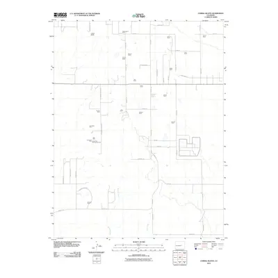
2010 Map of Corral Bluffs
USGS Topo · Published 2010About this map
The Corral Bluffs escarpment dominates the northern landscape of this region east of Colorado Springs, where a legacy of resource extraction and ranching is clearly preserved. Industrial history is concentrated along the N Franceville Coal Mn Rd, featuring the Franceville Mine, the Clara Belle Mine, and the Corley Coal Mine Number Three. These labels provide specific locations for genealogists and researchers tracing the coal mining activity that once fueled the local economy.
Find a feature on this map
53 named features on this map. Tap any name to fly to it.
Don’t see what you’re looking for? This feature index may not catch every label — zoom into the map to look around manually.
Map Details
Editions of this 2010 Corral Bluffs Map
This is the sole edition of this map. No revisions or reprints were ever made.
Other maps of this area

1893 · Big Springs
USGS Topo · 1:125,000

1893 · Colorado Springs
USGS Topo · 1:125,000

1909 · Colorado Springs
USGS Topo · 1:125,000

1942 · Colorado Springs
USGS Topo · 1:125,000

1948 · Falcon
USGS Topo · 1:24,000

1948 · Fountain
USGS Topo · 1:24,000

1948 · Falcon
USGS Topo · 1:62,500
1948 · Falcon NW
USGS Topo · 1:24,000

1949 · Corral Bluffs
USGS Topo · 1:24,000
1950 · Elsmere
USGS Topo · 1:24,000