
1968 Map of Corral Canyon
USGS Topo · Published 1973About this map
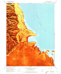
Stansbury Island rises sharply from the eastern edge of this 1960s orthophotomap, its steep slopes marked by Corral Canyon and Tabbys Canyon. The landscape is dominated by the industrial and ecological management of the Great Salt Lake shoreline, where Salt Evaporators and a Pumping Station signify the commercial extraction of minerals from the brine. To the west, the expanse of the Mud Flat is punctuated by the Timpie Springs Waterfowl Management Area, showing the efforts to preserve habitat amidst the saline environment. Infrastructure like the Protective Ditch and various Gravel Pits at the island's base reflect the mid-century development of Tooele County's natural resources. This hybrid survey combines traditional topographic contours with an aerial photographic base, capturing the precise state of the lake's water levels at a Normal Pool Elevation 4193.
Find a feature on this map
18 named features on this map. Tap any name to fly to it.
Don’t see what you’re looking for? This feature index may not catch every label — zoom into the map to look around manually.
Map Details
Editions of this 1968 Corral Canyon Map
This is the sole edition of this map. No revisions or reprints were ever made.
Other maps of this area

1885 · Tooele Valley
USGS Topo · 1:250,000

1953 · Tooele
USGS Topo · 1:250,000

1955 · Timpie
USGS Topo · 1:62,500

1955 · Burmester
USGS Topo · 1:24,000

1955 · Tooele
USGS Topo · 1:250,000

1968 · Plug Peak NW
USGS Topo · 1:24,000

1968 · Poverty Point
USGS Topo · 1:24,000

1968 · Badger Island NW
USGS Topo · 1:24,000

1968 · Badger Island
USGS Topo · 1:24,000
1968 · Plug Peak
USGS Topo · 1:24,000