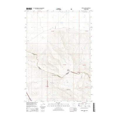
2014 Map of Corral Creek
USGS Topo · Published 2014About this map
The Continental Divide forms a high-altitude spine across this landscape, marking the jagged boundary between Beaverhead County, Montana, and Clark County, Idaho. This high-country terrain is dominated by the Western Centennial Mountains and the northern reaches of the Targhee National Forest. In the lower elevations of the Centennial Valley, seasonal drainage patterns like Sand Creek and Corral Creek flow toward the shallow basin of Mud Lake. The transportation network is sparse, reflecting the remote nature of the region, yet it includes specifically named corridors such as Whiskey Row and Price Lane. Local water sources like Boatman Spring serve as vital landmarks in a territory defined by its steep elevation changes and deep mountain drainages, including the headwaters of West Camas Creek and Price Creek.
Find a feature on this map
32 named features on this map. Tap any name to fly to it.
Don’t see what you’re looking for? This feature index may not catch every label — zoom into the map to look around manually.
Map Details
Editions of this 2014 Corral Creek Map
This is the sole edition of this map. No revisions or reprints were ever made.
Other maps of this area

1955 · Dubois
USGS Topo · 1:250,000

1957 · Paul Reservoir
USGS Topo · 1:62,500

1958 · Dubois
USGS Topo · 1:250,000

1968 · Corral Creek
USGS Topo · 1:24,000

1968 · Big Table Mountain
USGS Topo · 1:24,000

1968 · Lima Dam
USGS Topo · 1:24,000

1968 · Antelope Peak
USGS Topo · 1:24,000

1968 · Monida
USGS Topo · 1:24,000
1968 · Wolverine Creek
USGS Topo · 1:24,000

1972 · Spencer North
USGS Topo · 1:24,000