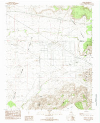
1985 Map of Correo
USGS Topo · Published 1985About this map
The Atchison Topeka and Santa Fe RR cuts a path through this high-desert landscape, following the course of the Rio San Jose as it traverses the Laguna Indian Reservation. Small settlement clusters like Correo, Suwanee, and Lucero appear as isolated outposts amidst the mesa-dominated terrain of the late 20th century. The presence of water sources such as Suwanee Spring and Coyote Spring, along with ranching infrastructure like Valentine Tank, highlights the essential connection between geography and survival in this arid region.
Find a feature on this map
23 named features on this map. Tap any name to fly to it.
Don’t see what you’re looking for? This feature index may not catch every label — zoom into the map to look around manually.
Map Details
Editions of this 1985 Correo Map
This is the sole edition of this map. No revisions or reprints were ever made.
Other maps of this area

1883 · Mt. Taylor
USGS Topo · 1:250,000

1886 · Mt. Taylor
USGS Topo · 1:250,000

1892 · Mt. Taylor
USGS Topo · 1:250,000

1899 · Mt. Taylor
USGS Topo · 1:250,000

1917 · Cerro Verde
USGS Topo · 1:125,000

1954 · South Garcia
USGS Topo · 1:24,000

1954 · South Garcia SE
USGS Topo · 1:24,000

1954 · Canoncito School
USGS Topo · 1:24,000

1954 · Socorro
USGS Topo · 1:250,000

1956 · South Garcia
USGS Topo · 1:62,500