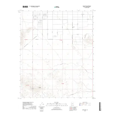
2018 Map of Cortez Peak
USGS Topo · Published 2018About this map
Cortez Peak rises as a prominent landmark within the northern reaches of the Gila Bend Mountains, overseeing a desert landscape defined by complex drainage systems and a rigid grid of access roads. The southern half of the map is dominated by the mountainous terrain where Copper Wash, Loudermilk Wash, and the notably named Fourth of July Wash carve through the topography. In contrast, the northern section transitions into the flat expanse of the Harquahala Plain. This area is marked by a transition from traditional desert tracks like W Clanton Trl and Arlington-Clanton Well Rd to a highly regularized system of numbered avenues and streets. The presence of Agua Caliente Rd and W Whitewing Pass suggests the historical and modern transit corridors used to navigate this arid environment in Maricopa County.
Find a feature on this map
48 named features on this map. Tap any name to fly to it.
Don’t see what you’re looking for? This feature index may not catch every label — zoom into the map to look around manually.
Map Details
Editions of this 2018 Cortez Peak Map
This is the sole edition of this map. No revisions or reprints were ever made.
Other maps of this area

1927 · Hyder
USGS Topo · 1:62,500

1930 · Hyder
USGS Topo · 1:62,500

1942 · Vicksburg
USGS Topo · 1:250,000

1951 · Dendora Valley
USGS Topo · 1:62,500

1954 · Phoenix
USGS Topo · 1:250,000

1957 · Phoenix
USGS Topo · 1:250,000

1958 · Phoenix
USGS Topo · 1:250,000

1960 · Phoenix
USGS Topo · 1:250,000

1962 · Cortez Peak
USGS Topo · 1:62,500

1962 · Eagletail Mts
USGS Topo · 1:62,500