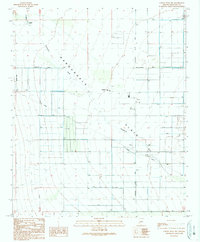
1990 Map of Cortez Peak NW
USGS Topo · Published 1990About this map
The Harquahala Plain defines this desert landscape, where a rigid grid of section lines and irrigation infrastructure meets the seasonal path of Centennial Wash. In this 1990 provisional update, the area's agricultural and rural character is evidenced by the concentration of wells and water management features like the Ditch, Levee, and an extensive Pipeline. Human activity is centered around the Harquahala Valley Sch and local thoroughfares such as Courthouse Road and Harquahala Valley Road. The map records a specific stage of development in Maricopa County, featuring isolated landmarks such as a Corral, Allison Tank, and a Trailer Park. These elements, along with the Landing Strip, suggest a landscape reliant on both traditional ranching and modern utility systems in a flat, arid environment.
Find a feature on this map
22 named features on this map. Tap any name to fly to it.
Don’t see what you’re looking for? This feature index may not catch every label — zoom into the map to look around manually.
Map Details
Editions of this 1990 Cortez Peak NW Map
This is the sole edition of this map. No revisions or reprints were ever made.
Other maps of this area

1942 · Vicksburg
USGS Topo · 1:250,000

1954 · Phoenix
USGS Topo · 1:250,000

1957 · Phoenix
USGS Topo · 1:250,000

1958 · Phoenix
USGS Topo · 1:250,000

1960 · Phoenix
USGS Topo · 1:250,000

1961 · Lone Mountain
USGS Topo · 1:62,500

1961 · Big Horn Mts
USGS Topo · 1:62,500

1962 · Cortez Peak
USGS Topo · 1:62,500

1962 · Eagletail Mts
USGS Topo · 1:62,500

1969 · Phoenix
USGS Topo · 1:250,000