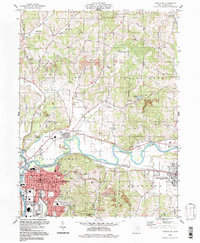
1994 Map of Coshocton
USGS Topo · Published 1998About this map
The confluence of the Walhonding River and the Tuscarawas River forms the Muskingum River here, a hydrological junction that defined the growth of Coshocton. The landscape is marked by the transition from industrial riverfronts to the elevated terrain of Hardscrabble Hill. Historically significant features like the Mudport Basin and the village of Canal Lewisville hint at the area's canal-era origins. To the west, the Richard Downing Airport and various Strip Mines reflect 20th-century economic shifts.
Find a feature on this map
55 named features on this map. Tap any name to fly to it.
Don’t see what you’re looking for? This feature index may not catch every label — zoom into the map to look around manually.
Map Details
Editions of this 1994 Coshocton Map
This is the sole edition of this map. No revisions or reprints were ever made.
Other maps of this area

1908 · Conesville
USGS Topo · 1:62,500

1909 · Cambridge
USGS Topo · 1:62,500

1910 · Conesville
USGS Topo · 1:62,500

1911 · Newcomerstown
USGS Topo · 1:62,500

1912 · Cambridge
USGS Topo · 1:62,500

1913 · Newcomerstown
USGS Topo · 1:62,500

1913 · Coshocton
USGS Topo · 1:62,500

1915 · Coshocton
USGS Topo · 1:62,500

1943 · Coshocton
USGS Topo · 1:62,500

1943 · Newcomerstown
USGS Topo · 1:62,500