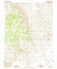
1982 Map of Coso Peak
USGS Topo · Published 1983About this map
China Lake Naval Weapons Center dominates this high-altitude Inyo County landscape, where restrictive boundaries signify the modern military use of an area once defined by remote mining and vital water sources. The map identifies the historic location of Coso (Site), appearing here as a site of archaeological and genealogical interest near the Josephine Mine and various unnamed prospects. The reliance on scattered water sources is evident through the naming of numerous springs, including Indian Gardens Springs, Mill Spring, and Chappo Spring, which likely dictated the movement of early prospectors and settlers.
Find a feature on this map
32 named features on this map. Tap any name to fly to it.
Don’t see what you’re looking for? This feature index may not catch every label — zoom into the map to look around manually.
Map Details
Editions of this 1982 Coso Peak Map
This is the sole edition of this map. No revisions or reprints were ever made.
Other maps of this area

1908 · Ballarat
USGS Topo · 1:250,000

1913 · Ballarat
USGS Topo · 1:250,000

1948 · Death Valley
USGS Topo · 1:250,000

1950 · Darwin
USGS Topo · 1:62,500

1951 · Darwin
USGS Topo · 1:62,500

1951 · Keeler
USGS Topo · 1:62,500

1951 · Haiwee Reservoir
USGS Topo · 1:62,500

1951 · Coso Peak
USGS Topo · 1:62,500

1954 · Death Valley
USGS Topo · 1:250,000

1956 · Death Valley
USGS Topo · 1:250,000