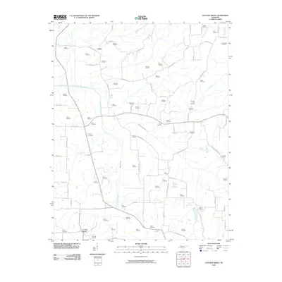
2010 Map of Cottage Grove
USGS Topo · Published 2010About this map
Cottage Grove serves as the primary settlement center in this part of Henry County, situated within a landscape defined by the winding course of the North Fork Obion River. The map reveals a dense network of family and community history, evidenced by an exceptional number of small, rural cemeteries that dot the countryside. Prominent watercourses such as Walnut Fork Creek, Mill Creek, and Pleasant Grove Creek carve through the terrain, dictating the placement of early road networks like Old Caldwell Rd and Martin Mill Rd. The distribution of these family burial grounds, including the Maxwell Cemetery, Kuykendall Cemetery, and Parrish Cemetery, suggests a long-established agricultural community where land ownership remained remarkably stable through generations. This detailed survey provides a clear view of the rural settlement patterns and hydrological features that have shaped the region north of the Obion River.
Find a feature on this map
91 named features on this map. Tap any name to fly to it.
Don’t see what you’re looking for? This feature index may not catch every label — zoom into the map to look around manually.
Map Details
Editions of this 2010 Cottage Grove Map
This is the sole edition of this map. No revisions or reprints were ever made.
Other maps of this area

1936 · Conyersville
USGS Topo · 1:24,000

1936 · Hazel
USGS Topo · 1:24,000

1936 · Crossland
USGS Topo · 1:24,000

1936 · Lynn Grove
USGS Topo · 1:24,000

1936 · Paris
USGS Topo · 1:24,000

1950 · Osage
USGS Topo · 1:24,000

1950 · Paris
USGS Topo · 1:24,000

1950 · Puryear
USGS Topo · 1:24,000

1950 · Cottage Grove
USGS Topo · 1:24,000
1951 · Hazel
USGS Topo · 1:24,000