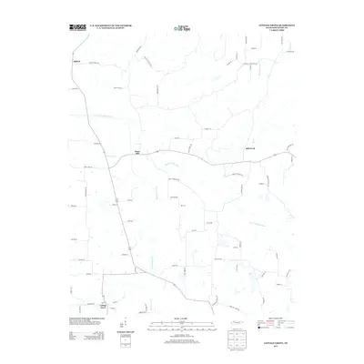
2013 Map of Cottage Grove
USGS Topo · Published 2013About this map
Cottage Grove serves as the primary community anchor in this rural portion of Henry County, situated among the headwaters and tributaries of the North Fork Obion River. The landscape is defined by a dense network of country lanes and creeks, reflecting a long history of agricultural settlement. Smaller centers such as Midway, Jones Mill, and Mill Creek are connected by roads that frequently bear the names of local families and early landmarks, such as Hayes Store Rd and Center School Rd. Genealogists will find particular value in the placement of Paschall Cemetery Rd and Cox Cemetery Ln, which point toward established local family burial sites. The drainage patterns of Walnut Fork Creek and Pleasant Grove Cr illustrate the undulating West Tennessee terrain that has shaped the placement of farmsteads and transport routes through the early 21st century.
Find a feature on this map
70 named features on this map. Tap any name to fly to it.
Don’t see what you’re looking for? This feature index may not catch every label — zoom into the map to look around manually.
Map Details
Editions of this 2013 Cottage Grove Map
This is the sole edition of this map. No revisions or reprints were ever made.
Other maps of this area

1936 · Conyersville
USGS Topo · 1:24,000

1936 · Hazel
USGS Topo · 1:24,000

1936 · Crossland
USGS Topo · 1:24,000

1936 · Lynn Grove
USGS Topo · 1:24,000

1936 · Paris
USGS Topo · 1:24,000

1950 · Osage
USGS Topo · 1:24,000

1950 · Paris
USGS Topo · 1:24,000

1950 · Puryear
USGS Topo · 1:24,000

1950 · Cottage Grove
USGS Topo · 1:24,000
1951 · Hazel
USGS Topo · 1:24,000