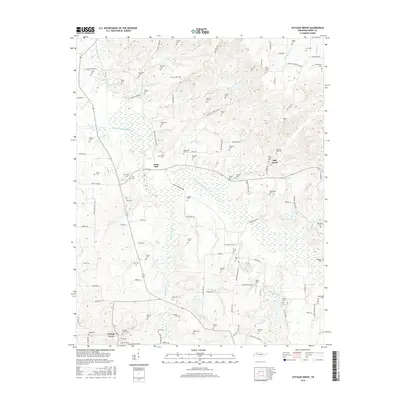
2016 Map of Cottage Grove
USGS Topo · Published 2016About this map
Cottage Grove serves as the primary hub for this rural Henry County landscape, where the agricultural grid is defined by a dense network of family-named cemeteries and historical crossroads. The terrain is deeply carved by the North Fork Obion River and its tributaries, including Walnut Fork Creek and Mill Creek. These waterways dictated the early settlement patterns of hamlets like Jones Mill and provided the natural boundaries for a patchwork of small homesteads. The sheer number of family burial grounds, such as Paschall-Wall Cem, Kuykendall Cem, and Brisendine Cem, offers significant insight for genealogists tracking the migration and establishment of local lineages. Transport routes like Jones Mill Crossland Rd and memories of old education centers found along Old Blake School Rd underscore the community's long-standing connection to this Tennessee countryside.
Find a feature on this map
112 named features on this map. Tap any name to fly to it.
Don’t see what you’re looking for? This feature index may not catch every label — zoom into the map to look around manually.
Map Details
Editions of this 2016 Cottage Grove Map
This is the sole edition of this map. No revisions or reprints were ever made.
Other maps of this area

1936 · Conyersville
USGS Topo · 1:24,000

1936 · Hazel
USGS Topo · 1:24,000

1936 · Crossland
USGS Topo · 1:24,000

1936 · Lynn Grove
USGS Topo · 1:24,000

1936 · Paris
USGS Topo · 1:24,000

1950 · Osage
USGS Topo · 1:24,000

1950 · Paris
USGS Topo · 1:24,000

1950 · Puryear
USGS Topo · 1:24,000

1950 · Cottage Grove
USGS Topo · 1:24,000
1951 · Hazel
USGS Topo · 1:24,000