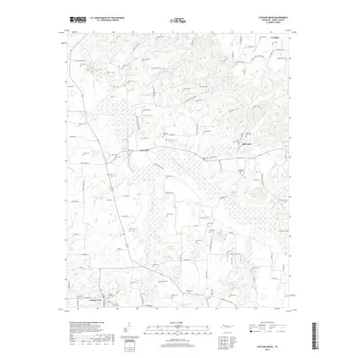
2019 Map of Cottage Grove
USGS Topo · Published 2019About this map
Cottage Grove serves as the primary hub in this corner of Henry County, where the landscape is defined by the wetlands and drainage systems of the North Fork Obion River and its tributaries. The terrain is deeply inscribed with family history, evidenced by a dense network of burial grounds like Kuykendall Cem, Paschall-Wall Cem, and Lassiter Cem that dot the ridges between creek valleys. Small rural clusters such as Jones Mill and Mill Creek appear alongside the winding courses of Terrapin Cr and Walnut Fork Cr. The road network, including Jones Mill Crossland Rd and Osage Crossland Rd, connects these isolated settlements to the larger village of Crossland in the northeast. This 2019 survey provides a clear view of the contemporary rural structure, where traditional property lines and family landmarks remain central to the community's geographic identity.
Find a feature on this map
112 named features on this map. Tap any name to fly to it.
Don’t see what you’re looking for? This feature index may not catch every label — zoom into the map to look around manually.
Map Details
Editions of this 2019 Cottage Grove Map
This is the sole edition of this map. No revisions or reprints were ever made.
Other maps of this area

1936 · Conyersville
USGS Topo · 1:24,000

1936 · Hazel
USGS Topo · 1:24,000

1936 · Crossland
USGS Topo · 1:24,000

1936 · Lynn Grove
USGS Topo · 1:24,000

1936 · Paris
USGS Topo · 1:24,000

1950 · Osage
USGS Topo · 1:24,000

1950 · Paris
USGS Topo · 1:24,000

1950 · Puryear
USGS Topo · 1:24,000

1950 · Cottage Grove
USGS Topo · 1:24,000
1951 · Hazel
USGS Topo · 1:24,000