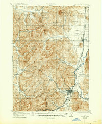
1921 Map of Cottage Grove
USGS Topo · Published 1947About this map
Cottage Grove serves as the focal point for this survey, situated where Silk Creek and the Coast Fork Willamette River converge. The landscape is defined by its early 20th-century transportation and industrial networks, notably featuring the Southern Pacific line and the Oregon Pacific and Eastern Ry extending eastward. A unique industrial feature, the Flume Line, follows the terrain near Veatch Creek, hinting at the timber and resource extraction vital to the Lane County economy at this time.
Find a feature on this map
33 named features on this map. Tap any name to fly to it.
Don’t see what you’re looking for? This feature index may not catch every label — zoom into the map to look around manually.
Map Details
Editions of this 1921 Cottage Grove Map
3 editions found
Other maps of this area

1909 · Elmira
USGS Topo · 1:62,500

1910 · Eugene
USGS Topo · 1:62,500

1921 · Cottage Grove
USGS Topo · 1:62,500
1922 · Elmira
USGS Topo · 1:62,500

1935 · Lowell
USGS Topo · 1:96,000

1940 · Eugene
USGS Topo · 1:62,500

1942 · Lowell
USGS Topo · 1:125,000

1942 · Elmira
USGS Topo · 1:62,500
1942 · Crow
USGS Topo · 1:62,500

1945 · Crow
USGS Topo · 1:62,500